Brougham Road

014Brough

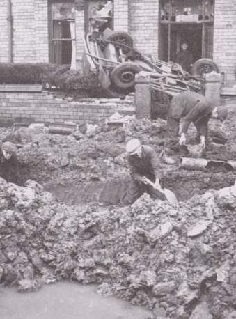
The photograph above shows damage done to number 32 Brougham Road, Wallasey during the December Blitz. It has appeared in many books about the blitz on Merseyside and even appeared in the Daily Post on the 23rd December 1940. It is a fascinating image as it shows not just damage to the roadway, but also that the explosion has thrown a car up in the air, with it coming to rest upside down between the doorway and wall of number 32.

I included the photograph in my second book: Merseyside Blitzed with the usual direct comparison with the modern viewpoint below

015Brough

In keeping with a lot of my recent work though, I particularly wanted to get another modern photograph in order to create a ghost image (one where the modern and wartime photograph are merged). I managed this a short time ago, then posted the results to my Facebook author page and shared it with several groups. The response was very positive, especially on a group called Wallasey Memories (link below) where something quite amazing happened.

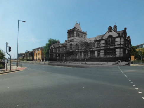
Brougham Road cropped

First of all one of the members mentioned that they used to live at number 30, and recalled “the roof next door was never straight”. This was followed by Angela Cooper and Sandra Topping, sisters who lived at number 32 itself in the 1980s, when it was their family home.

A major contribution came soon after from Ken Clark, a fellow photographer who also does both “then and now” and ghost photos of the local area. It seems that this kind of work runs in the family, for Ken posted a slide with photographs originally taken by his uncle. Ken’s uncle served in the RAF during the war, and saw much of the damage first hand whilst on leave.

For many years he gave talks which included then and now photographs. When taking the post-war photos he would often speak to the current residents of the properties concerned, and if they agreed, include them in the photograph. His photograph of Brougham Road therefore included Sandra and Angela’s parents, Arnold & Betty Williams standing outside, who are sadly no longer with us.

Ken Uncle Comparison Ken Uncle original

It was a real pleasure to hear everyone’s connection to the photograph, and see how a few images can be very powerful, bringing together people around a common interest. It also allows even those unfamiliar with the property to gain an appreciation of the scale of damage that Wallasey suffered, and the unusual sights that people alive during the Blitz would have witnessed.

Wallasey memories group: https://www.facebook.com/groups/liberator31/


Private Frederick Hopwood

Although not related to the Blitz, the following article is about an interesting aspect of local history. Written by me, it originally appeared in the quarterly newsletter for the friends of the Airborne Museum “Hartenstein”.

FB

The photograph above is of a field grave of a British soldier in the Netherlands during WW2 which has appeared in several publications about the fighting in Arnhem. Until now relatively little was known about the paratrooper who was buried there, beyond his name, army number and date he fell. This article will provide a snapshot of one of the brave airborne soldiers who took part in the Market Garden Campaign.

My own connection to the story came about purely by chance. I live on the Wirral, a peninsula near to Liverpool, Wales and Chester. As a keen hiker I often enjoy walking through the nearby villages and towns and on one of these trips came across the tiny village of Shotwick. Located on the Dee Estuary, only 8 miles from Chester, it has a wonderful old church, in the grounds of which was the war memorial below with six names. One of these names stood out as unusual since it listed the date and place of death, something not normally seen on British memorials.

Memorial

I noted down the details – “Frederick Walter Hopwood, killed in action at Arnhem, 18th September 1944” and decided to do some research when I got home. A quick internet search resulted in the photograph of Frederick’s field burial, along with information about where he had fallen. Strangely, the date on the war memorial contradicted the date on the field burial, which lead in turn to me wanting to find out much more about this man’s story.

One of the wreaths attached to the memorial included a dedication from “Sons Fred, Reg and surviving family members”. Through the Churchwarden I was able to contact Frederick’s family, eventually meeting his niece and having a long telephone conversation with his younger son. Their help and information was essential in compiling this article, as was support from a Dutch friend called Tom Timmermans who has also studied Frederick’s story and helped with some of the research.

Frederick was born on the 16th July 1917, the youngest of six children born to James and Emily Hopwood. In civilian life he worked as a train fireman at the local steelworks, a huge complex in the nearby town of Shotton which employed thousands of people and used more than 30 steam trains. Several members of his family also worked at the steelworks, as did many friends. The family lived at Bank Farm in Shotwick and worshipped at the church of St Michael’s in the village.

He enlisted in the army at Catterick Garrison on the 15th March 1940 and as was standard by then, signed up for “DOW” i.e. the duration of the war. At 5 feet 5 inches (165cm) he was shorter than average, but was also well built at 147lbs (67kg). He was also very athletic and enjoyed boxing.

Unclefred

An early photo of Frederick in Uniform, probably taken shortly after joining up.

His initial service was with an anti-aircraft unit, with which he was posted to various locations, including Whiltley Bay in the North East of England. Whilst serving there he met a local girl called Mabel and they were soon married. Returning to Cheshire, the family moved to a house in nearby Mollington. On the 14th May 1943 his first son, also called Frederick was born.

The exact details of when and where he served prior to Arnhem are uncertain, but some information can be deduced from surviving letters and documents in the family’s possession. Many of these were in a wallet that was recovered from his body by a chaplain shortly after he was killed (more on this later).

A British Army African campaign booklet, along with an Algerian 5 Franc Note confirms that he served in the Tunisian campaign that followed the Allied landings in Operation Torch. He also possessed several Italian notes, at least one of which was printed by the Allies, showing that he must have also served in either Sicily, Italy, or both.

Putting these notes together with the fact that he served with 3rd Battalion, the Parachute Regiment at Arnhem suggests that he was quite probably with the battalion since 1942, as it served in all of those places before being withdrawn to the United Kingdom in December 1943. Sadly his best friend, Reg Madeley was killed in Tunisia. Frederick’s second son, born two months after the battle of Arnhem would be named Reg in memory of that fallen friend.

Frederick Hopwood

A photograph of Frederick taken later in the war, probably in either Africa or Italy. On his right shoulder the jump wings that mark him out as a member of the Parachute Regiment can just be made out.

Along with the rest of 1st Airborne Division, Frederick’s battalion spent the next 9 months preparing for deployment in North West Europe. For Market Garden his unit dropped onto Drop Zone “X” at around 2pm on the 17th September 1944. After a brief delay whilst the battalion formed up, the troops moved off on their planned route to Arnhem. Named “Tiger” route, this would take it through Oosterbeek on the Utrechtseweg. Sadly this route would bring it into direct contact with a German blocking force under the command of SS Sturmbannfuhrer Sepp Krafft.

As the troops approached the junction of Utrechtseweg and Wofhezerweg they came under fire, initially from a self propelled flak gun and then from mortars and machine guns. What exactly happened to Frederick will probably never be known, but he almost certainly fell in this engagement. The damage to his wallet (seen below) and the documents within suggest that he was probably killed by a piece of shrapnel rather than a bullet. A chaplain recovered his belongings, keeping hold of them for most of the battle, no doubt hoping to return them to his next of kin.

OLYMPUS DIGITAL CAMERA

He was buried where he fell, his Lee Enfield rifle placed in the ground to mark the spot. The tide soon turned against the paratroopers though and as we all know, the division eventually had to be evacuated across the Rhine. Along with many others, the chaplain volunteered to stay with the wounded, but passed his collection of belongings onto a pilot who had been shot down earlier in the fighting. The pilot was one of those lucky enough to get across the river and back to Allied lines, so was able to pass the possessions back to Frederick’s battalion.

In addition to the wallet was Frederick’s red beret, the iconic symbol of his elite status as a British paratrooper. Two smaller items were his identity disc, which gave his name and army number and an unusual badge. Given the stylised wings it would be easy to assume this was some form of regimental cap badge, but none like it exists in the British Army. After an extensive search online using the three visible letters “G T W” it turned out to be a membership badge for the Transport and General Workers Union, an organisation Frederick probably joined whilst he was working at the Steel Works.

OLYMPUS DIGITAL CAMERA

The family knew none of this, as was usual during wartime since it was often difficult to obtain accurate casualty lists. Like many families, they received an initial notification from the War Office that he was listed as missing in action. In Frederick’s case this arrived in mid October 1944. Two months later they received his belongings in the post, the first real indication of his fate. They arrived on the very day that his second son was christened.

HopwoodMonumentNL1

Frederick’s grave in Oosterbeek Cemetery. Photograph reproduced with the kind permission of Tom Timmermans

Official notification of his death from the War Office was not sent until June 1945, presumably after his field burial had been located. The photograph of the field grave was taken by a German photographer and first appeared in Berliner Illustrierte Zeitung in November 1944. The photographer was probably in the area at the time to see where General Kussin had been ambushed and killed, since Frederick’s grave is only a short distance away.

Hopwood_Fieldgrave_Now

A modern view of the spot where Frederick Fell. The brick structure is a gate post for Hoog Oorsprong. Photograph reproduced with the kind permission of Tom Timmermans

For some reason the War Office recorded his death as occurring on the 18th September, which is unlikely as the battalion had moved further down Utrechtseweg by then. This official date was later used in formal documents, his grave in Oosterbeek Cemetery and on the War Memorial in Shotwick churchyard.

It is difficult for us to imagine how much of a shock Frederick’s death must have been to his family, friends and especially his young wife. Some indication of his popularity can be taken from the fact that his former colleagues at the Steelworks raised a total of £12.50 for Mabel and the children, a large sum in those days.

Like so many of his comrades in 1st Airborne Division he was eventually laid to rest in Oosterbeek Military Cemetery. His final resting pace is Plot 22, Row B, Grave 12. In 1966 Mabel remarried, but tragically died shortly after in a fire. Both sons are still alive and used to be regular visitors to the Arnhem area during the anniversary commemorations. They both speak very highly of the way that local people treat veterans, their families and the war graves.

The family are grateful for the opportunity to update Frederick’s story and make a wider audience aware of his sacrifice.



A Downed Bomber

I was recently contacted on Facebook by Phil Williams who asked me:

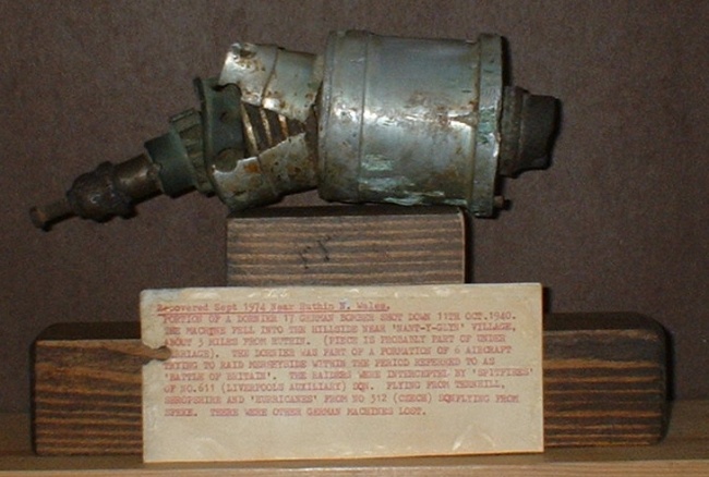
I have come across something you might be interested in. When I was a kid my dad got me a piece of a German bomber shot down after attacking Liverpool. It came from the Fort Perch Rock collection. It also came with some paperwork about the attack. Its all mixed up and a bit confused, but if you sit down and work it out its quite good.

Phil emailed me the various files, the first of which is a photograph of the piece itself.

Image

With a closer photograph of the information card

Image

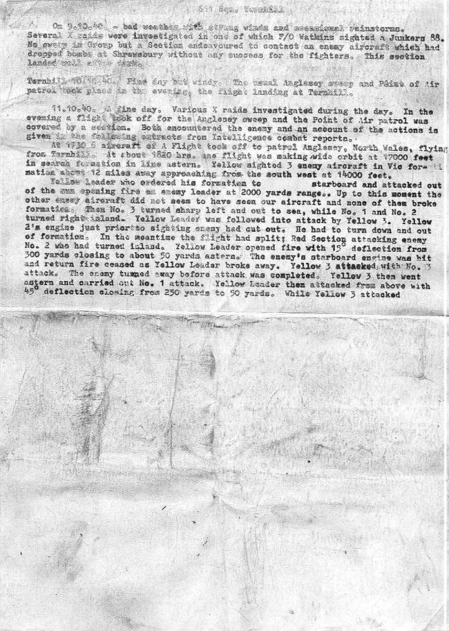
As Phil says, the information is somewhat patchy and hard to put together, but helping matters somewhat were the following files that came with the above.

ImageImageImage

These are not the easiest things to make out as Phil said in his email, but essentially they contain action reports for a number of RAF fighters that engaged the Luftwaffe bombers in the early evening of the 11th October 1940. Most of this action took place over Wales, with the first three enemy planes (those attacked by Yellow and Red sections) being brought down near the flight’s normal sweep area of Anglesey. Blue section however seems to have engaged enemy bombers much closer to Merseyside, and it is these two planes that are more interesting for the purposes of this article. Given that the approach route for Luftwaffe attacks on Merseyside passed over the North Wales coast though, it is quite probable that all of these planes were planning on attacking this region. Part of the third image also refers to the Germans loosing 5 bombers on that night – 3 of which match the losses to Red and Yellow sections, leaving one bomber listed as crashing on returning to Brest (Northern France) and the last plane recorded as lost “near Chester”

Turning to the details of the RAF reports, in summary we know that one of the planes was chased around Wirral and North Wales (where it dropped several bombs), before the fighters lost sight of it near Denbigh. The other was attacked near the Welsh coast around Prestatyn, had parts shot off its underside, and was last seen over Liverpool Bay.

The information card included with the piece tells us that the bomber was recovered at “Nant-y-Glyn village, about three miles from Ruthin” but this would appear to be a mispelling of Nantglyn, which is the only village nearby with that name. Given its proximity to Denbigh, this might lead us to conclude that the first bomber last seen in that area came down at Nantglyn, however the RAF pilots said she was last seen heading north from Denbigh (towards the coast), whereas Nantglyn is to the South West. Having already dropped several bombs and last been seen heading back on its usual route home, it seems unlikely that the Luftwaffe crew would have chosen to in effect turn around and fly back over land.

So this leaves the final plane, the one last seen over Liverpool Bay does it not? Not necessarily, although it is entirely possible that this is our plane. The reason for such doubt is connected to a follow up question Phil asked me: “Just as a side thought, do you have any info on damage caused that night ?”

The following is an extract from the Liverpool Police’s post-war summary of the blitz

————————
11/12 October 1940
City and North Docks attacked in first raid [from 18:38 to 19:49], severe damage South John Street, James Street, Redcross Street, Paradise Street, Hannover Street, South Castle Street. HE [High Explosive] on Alexandra and Langton Docks, causing serious damage to dock sheds, Harbour Master’s House and four ships.
Second raid [from 21:00 to 23:23] on Hill Street and Bankhall Street areas, damage to railway track and admiralty strores.

——————–

The Fire Brigade records say much the same, albeit in less detail. I haven’t done a thorough check but I think about a dozen people were killed that night in Liverpool.

As you can probably tell, the attack on Liverpool that night was particularly heavy and would have involved a large number of enemy planes, any one of which may have been damaged by anti-aircraft fire or a night fighter and brought down over North Wales. The fighters in the action reports clearly encountered one small part of the raiding force, perhaps even its leading elements since the dogfights were largely over by the time the main raid was getting underway.

Phil is hoping to follow up the item more himself, for I imagine that the Fort Perch Rock Museum would have had a good reason for identifying the piece as part of a bomber brought down in that night’s raid. Whether it was – as the museum felt – one of the planes engaged by the RAF fighters in the late evening, or one of the bombers involved in the larger raid would be interesting to find out, so if I get any updates I will keep you posted.

Fountains Road area

Fountains 2.bmp

This photograph has been variously described as either “Walton Road”, “Fountains Road” or even “County Road” in Liverpool. I was recently contacted by Ed through Facebook with the following query:

I wonder if you could tell me where the exact location of this pic. I’ve seen it described as “Royal St” off Walton Road but someone now tells me it could be Fountains Rd/Barry St. Any idea?

My gut feeling leaned towards the Royal Street area for several reasons:

1) Whenever mention was made of the Fountains Road area it was always in relation to other parts of the road

2) The layout of the roads in each area at first glance seemed to suit Royal Street better

3) A quick check of the Roll of Honour suggested that more deaths occurred in the Royal Street area

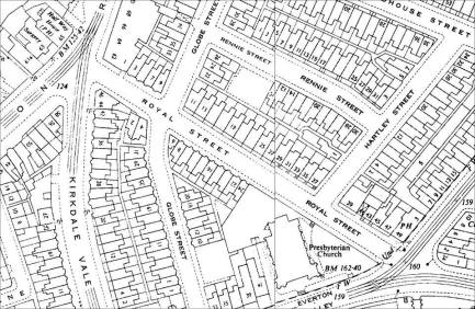
However Ed and Dave Bridson came up trumps with a couple of post-war O/S maps that cleared up the question straight away. First up comes the area around Royal Street – largely unchanged with no signs of large areas of empty land through war damage.

1604572_252920338219904_658109951_n

Then we have the area around the junction with Walton Road, Fountains Road, Woodhouse Street and Wyatt Street. You can clearly see large gaps in this area which match the damage seen in the wartime photograph.

1601550_252920458219892_1757585104_n

This lead me to ponder why this particular area wasn’t singled out for a mention in books like Port in a Storm (PIAS) or similar. This book is an excellent guide to the May Blitz on Liverpool, covering the events in great detail. Whilst it is possible that the damage in the photograph occurred during another period of the blitz, I knew from prior research that the Fountains Road area took a battering during the May Blitz.

For the Fountains Road area on the night of the 3rd/4th May 1941 PIAS mentions:

Fountains Road area – notably Wykeham, Newman, Morley and Freeland Streets (100) [100 being the number of deaths]

The road is also mentioned as being hit on the nights of the 2nd/3rd May 1941 and the 4th/5th May 1941 but no mention of the area covered by the photograph is made.

Other sources cite the number of deaths on Fountains Road alone as 22, which is quite a difference from 100. A study of the roads mentioned however reveals that the author of PIAS is talking about a pretty big area, which can be best seen on the pre-war map below (click on the map for a better view of it).

Fountains

The numbers in red represent the number of deaths associated with that particular road, whose date of death is given as sometime during the May Blitz. Note that not all of these would have fallen on the 3rd/4th – for example the 6 losses at Chancel Street are known to have occurred the previous night.

Also “B” represents the approximate location of where a photographer would have stood to take the wartime photograph, whereas “A” represents approximately where I thought it may have been taken had the subject been Royal Street.

This should help clear up what John Hughes meant in PIAS when he referred to the Fountains Road area suffering around 100 deaths on the night of the 3rd/4th May 1941. It is difficult to be certain in every single case which night the person was killed on,  since the roll of honour only gives one date. Someone listed as dying on the 3rd May 1941 for example could have fallen on either the night of the 2nd/3rd 1941, or the night of the 3rd/4th 1941. With this in mind though, the list is as follows:

Wykeham Street: 13

Newman Street: 11

Beckett Street: 1

Chancel Street: 6

Freeland Street: 24

Tintern Street: 1

Woodhouse Street: 4

Walton Road: 1

Royal Street: 5

Hartley Street: 1

Morley Street: 18

Fountains Road: 22

Howley Street: 4

Total: 111

This explains why the area in the photograph is not generally mentioned in reference books. Although the damage was very severe, there were likely only four deaths in that immediate area. Every death is a tragedy and that person would have been greatly missed, but the area in our wartime photograph saw fewer fatalities than many other locations in this area.

To round off this article I have included more post-war maps from Dave Bridson showing probable bombs sites in the Fountains Road area. I am grateful to both Dave and Ed for their help compiling this article, and especially clearing up the mystery photograph!

1795034_10152188390937500_149020339_o

1902240_10152188392882500_701978433_o

1920815_10152188392337500_1382745857_o

Youtube Video

Youtube Video

I thought I’d share this video with you all. Its an introduction to my two books about the air raids on Merseyside during World War Two. All credit for the video goes to Bob Edwards who kindly created it for me.

Please also note that this is not a Halsgrove video, just a video of my own created by my friend to advertise the books, which are published by Halsgrove.

The Merseyside Blitz: A spotters guide

More than seventy years after the raids that devastated so much of the region, you might think that spotting signs of the impact of the raids could prove difficult, at least without a handy reference guide. In many cases this is correct, for the region has seen massive changes in those seven decades, with whole areas rebuilt to such an extent that they would be unrecognisable to someone alive at the time of the attacks. There is however still signs of the blitz for anyone to see and this article will take you through some of them.

Signs and portents

Here and there throughout the region you will occasionally see signs for companies which have long since moved on or shut down. These are known as “Ghost Signs” and there is a rather excellent book on the subject by Phil and Caroline Bunford, which includes several wartime examples. One of these is this first sign, from the side of a building on Eberle Street (off Dale Street).

DSCF0358

Although as their book says, this sign looks like it’s in too good a condition to be an original, it certainly wouldn’t be surprising if it was, for the style and nature of the sign is perfectly in keeping for the times. It of course indicates an exit from a shelter, in this case in the basement of a prominent building. The Civil Defence workers would find such signs a great help, for if they had to rescue people from the building if it collapsed, knowing the location of emergency exits would save crucial minutes.

DSCF3437 (2)

Our second sign comes from a building in New Ferry currently occupied by Andy’s Aquatics. It indicates the direction of an Emergency Water Supply site. Created after the early raids, these supplies could take many forms, including swimming pools and the basements of demolished buildings that had been filled with water. This particular example may refer to the old New Ferry baths which were in the direction indicated by the arrow.

Visual signs of the past

Often you can tell from looking at a building when it has undergone some reconstruction in the past. Take the example of the building below, which was part of the hydraulic system used in the docks on the Wirral.

009Pumpho

You can quite clearly see the difference in colour between the bricks one the near corner of the building and the rest. The uneven line running down the wall suggests that this reconstruction wasn’t part of a planned rebuild, so it came as no surprise to find that the building was badly damaged during the blitz, with the damage corresponding almost exactly to the newer brickwork.

Another way is to look for remaining older features that look out of place with their surroundings. For example look at the balustrades surrounding the car park in this modern photograph.

Articles

It looks rather unusual and slightly out of place, although not impossible of course given the prominent location (on Victoria Street, the car park is used by the Municipal Annexe, whose tower can be seen in the photo). A study of the wartime photos however reveals that the balustrades in fact once surrounded a rather grand building known as Government Buildings, which was burnt out during the May Blitz.

A newer model

You can also often tell when a building has been damaged by a quick comparison of its age and current style. The photo below for example shows the Bootle Protestant Free Church.

231BooPro

Knowing that a church by the same name appears in the pre-war street directories provides a clue that it was probably hit during the raids. This building looks fairly modern and its style is quite likely post war. Sure enough, the archives contain a photograph of a building of similar layout, but quite different style, with heavy damage to the front of the building and its roof.

Mind the gap

Another common way to tell a blitz site is almost the reverse of the Government Buildings example, namely to look for modern properties or developments that look out of place with the theme of the area. One of the first photos I ever investigated was just labelled “Leopold Street” in the archives.

252Leopo

A visit to the street in question (in Kensington, Liverpool) revealed it was a street of almost entirely terraced housing, with the two notable exceptions (above). Nothing their numbers (77 and 79, but there was no 81 or 83), I then matched the names in the street directories for the period to the lists of civilian war dead, and was able to confirm this was the exact location. Four pre-war houses had been demolished and only two rebuilt, each with its own garage. A mother and four daughters had been killed at number 81.

Another common feature of post-war reconstruction is when the bomb site is never really built upon after the raid. Often you will find the site converted into another use, such as this one from Laird Street in Birkenhead.

106Laird

The gap in the centre of the photograph is where 62-68 once stood, which doesn’t appear to have been built upon after the war. Instead it became the home to a set of billboard advertisements, perhaps a temporary solution to cover the eyesore that eventually became permanent.

Conclusion

So there we are, a quick guide to the kinds of things to look out for on your travels around the Merseyside region. Do you know any examples yourself? If so please get in touch, I would especially love to hear about any other examples of the signs I mentioned.


Some sort of new articles on their way

The reason why I’ve said they are sort of new is because a good friend of mine, Bob Edwards runs an excellent website called Liverpool Picturebook and I have contributed several articles to that site over time. With Bob’s permission I will be adding those older articles to this blog.

Please do check out his website though, on it you can find historical photos from every corner of Liverpool (and some areas beyond such as Bootle or New Brighton). I must add a health warning before posting the link though: Beware, for if you are interested in local history, you could well lose an hour or two once you start to look around!

http://www.liverpoolpicturebook.com/

Also if you have chance his excellent book: Liverpool in the 1950s.

http://www.amazon.co.uk/dp/0752487884?tag=liverpopictur-21&camp=1406&creative=6394&linkCode=as1&creativeASIN=0752487884&adid=07AWN3915NEY0ARP22WH&&ref-refURL=http%3A%2F%2Fwww.liverpoolpicturebook.com%2F

Mistakes and corrections

A major part of any historian’s role is research, no non-fiction book worth reading would be possible without this. Sometimes, even with the best of intentions it is possible to make a mistake, to misread or misunderstand something. At other times it could simply be the case that the correct information was not available at the time of writing. There is also of course the possibility that the author made a genuine mistake, missing something obvious, guessing incorrectly or not having the time to  look into a subject as much as he would like before going to print.

Some degree of error is inevitable with any history book, but once discovered, these should be highlighted and if possible corrected. When the information is solely published online this is relatively easy, as the correct information can simply replace the older, incorrect one. When a book has been printed however this is not so simple, as the information can only be corrected if the book is reprinted.

Having come across several examples in my own work over time, I promised myself and my readers (online or in print) that I would eventually publish an article outlining these errors. I feel I owe as much to those that follow me, and above all to those who lived through the events.

I would also encourage anyone who feels they have noticed an error not listed here to contact me directly and if correct, I will add it to this list.

Liverpool Blitzed: 70 Years on

Cleveland Square, page 115

Contrary to the statement in my book that “despite several injuries, no-one was killed” when a bomb hit a shelter in the square, there was in fact at least 16 deaths connected to it. I really have no explanation for this mistake as part of my normal method of research includes searching an electronic record of the Civilian Roll of Honour, where all of the names appear. I can only apologise.

Page 138: Durning Road

“… Occurred on the night of the 29th November 1940” Should read “… Occurred on the night of the 28th/29th November 1940”

Merseyside Blitzed

Page 22: Lancaster Avenue

“In the early morning of the 12th March 1941” should read “In the early morning of the 13th March 1941” since the raid took place on the night of the 12th/13th March 1941.

Page 56: Severn Street

Since publication I have found out that the damage seen in the photograph was done on the 12th/13th March 1941, not the 21st/22nd December 1940

Page 101: Power Road

Since publication I have found out that the damage seen in the photograph was done on the 22nd/23rd October 1941, not the 20th/21st October 1941. The two people listed as fatalities also died on the night of the 22nd/23rd when this damage was done.

Page 113: Balliol Road School

A quite bad case of mistaken location. During my research on the Bootle area I came across this wartime photograph of the Boys Secondary School Municipal Technical School. I included the comparison below in my book assuming, based on a misreading of pre-war street directories that it lay between Queen’s Road and College view (on the left hand side of the road as you look towards the river). In fact the building stood on the opposite side of Balliol Road, where part of Hugh Baird College stands today.

Image

Since the publication of my second book I have worked on a ghost image for the correct location. It is still a bit of a work in progress, but you can see it below

Image

For all these errors I can only apologise.

Introduction

Hi everyone, my name is Neil Holmes and I am the author of two local history books about the Blitz on Merseyside. I was born on the Wirral in 1979 and still live there today, but work in Liverpool as a civil servant. I have studied military history for fifteen years and the history of the Merseyside region for six. My interest in local history and photography led me to research Liverpool’s wartime experiences, culminating in the publication of Liverpool Blitzed: 70 Years On in 2011, followed by Merseyside Blitzed the following year.

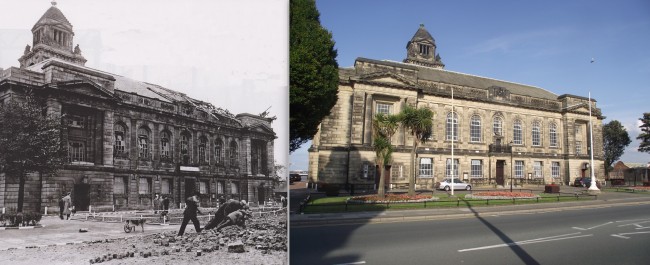
Most of the work so far comes in the form of “Then and now” shots of the blitz, showing a wartime photograph alongside its modern equivalent, or the closest possible comparison. This example below is from the Wallasey Blitz and shows damage done to the Town Hall on the night of the 31st August/1st September 1940. Fortunately the building survived the damage and remains standing to this day.

Image

In addition I also work on something called “Ghost photographs” where the wartime and modern photograph are merged together to create one image. This example comes from Birkenhead and shows the premises of Bolton’s garage and Taxi firm in Devonshire Road, hit on the night of the 12th/13th March 1941.

Image

I intend to use this particular blog to promote knowledge and understanding of the blitz on Merseyside, in particular its impact on the area around us and those who lived through those dark times.

You can also follow me at these places:

Twitter account: @liverpoolblitz

Facebook: https://www.facebook.com/Liverpoolblitz

Flickr: http://www.flickr.com/photos/34388583@N08/